Update –
About 4 hours ago • Aug 10 at 4:41 PM


All aircraft have been released from the incident, per Air Attack.
About 5 hours ago • Aug 10 at 4:28 PM
Forward progress of the fire has been stopped. Evacuation orders and warnings remain in place.
– per CAL FIRE Amador-El Dorado Unit on Facebook
SOMERSET, Calif. — A fast-moving vegetation fire burning near Hawk Haven Lane southeast of Somerset prompted a mandatory evacuation order Monday afternoon as firefighters worked to contain flames spreading through grass and vineyards.
The fire, identified as the Hawk Fire, was reported in the 7,000 block of Hawk Haven Lane. At approximately 2:17 p.m. Monday, Aug. 10, Air Attack estimated the fire at 15 to 20 acres.
Local evacuation requests were made as firefighters confronted the blaze in an area characterized by rural homes, vineyards, grasslands and narrow country roads.
Mandatory evacuation ordered
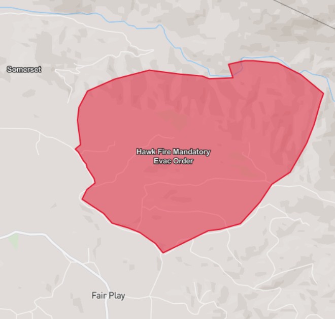
The El Dorado County Sheriff’s Office has issued a mandatory evacuation order for the Somerset Perimeter Zone encompassing the area from Hawk Haven Lane to Perry Creek Road and from Gray Rock Road to Slug Gulch Road.
Residents inside the affected area should leave immediately.
Officials are directing evacuees to use Fairplay Road and Mount Aukum Road.
The emergency notice states: “Please drive safely and stay out of the area, there are emergency responders in the area.”
Residents should not return to the evacuation area unless authorities officially lift the order.
Fire location being refined
The reported location of the fire has also been adjusted as aerial resources continue mapping the incident.
Flight data from aircraft operating over the fire indicates the mapped fire location has shifted approximately 0.42 miles west from its earlier position. Such adjustments are not unusual during an active wildfire as aircraft and ground crews obtain more precise information about the fire’s perimeter and movement.
The fire’s estimated size remains preliminary and could change as additional mapping is completed.
Placerville Library designated evacuation point
A temporary evacuation point has been established at the Placerville Library, 345 Fair Lane, Placerville, for residents displaced by the fire.
The library has served as an emergency gathering location during previous El Dorado County wildfires. CAL FIRE also designated the Placerville Library as a temporary evacuation point during the 2026 Miners Fire near Pilot Hill and during previous fires in the county.
Residents evacuating should travel carefully and follow directions from law enforcement and fire personnel. Officials are asking the public to stay away from the fire area so emergency crews can move equipment and personnel safely.
A familiar wildfire landscape
The Hawk Haven-Perry Creek area is part of the rural foothill landscape south and east of Somerset, where vineyards, grasslands, oak woodland and scattered residential properties meet.
The geography also has a recent history of wildfire evacuations. During the 2021 Caldor Fire, evacuation orders included the intersection of Perry Creek and Hawk Haven, portions of Fairplay Road and areas extending toward Slug Gulch and Omo Ranch.
That history underscores the importance of taking evacuation orders seriously in the region, where limited rural road networks can become congested quickly when large numbers of residents attempt to leave simultaneously.
Residents urged to leave before conditions change
For residents within the mandatory evacuation zone, the message from emergency officials is straightforward: leave now rather than waiting for the fire to approach homes.
Residents should take essential medications, identification, important documents, pets and other critical items if they can do so safely without delaying their evacuation.
Fire conditions can change rapidly, particularly when wind shifts or fire moves through continuous grass and other receptive fuels.
The public should avoid driving toward the fire to observe or photograph the incident. Emergency access is needed for fire engines, water tenders, law enforcement vehicles and other emergency resources.
CAL FIRE notes that wildfire evacuation orders represent an immediate threat to life and that areas under an evacuation order are closed to public access.
This is a developing story. Fire acreage, evacuation boundaries, road conditions and other incident information may change as firefighters continue operations. Residents should monitor official El Dorado County Sheriff’s Office, CAL FIRE Amador-El Dorado Unit and emergency alert channels for the latest evacuation information.
Sources: CAL FIRE; El Dorado County Sheriff’s Office emergency information; incident information provided from Air Attack and field reports; flight-tracking information associated with the active incident. Historical evacuation information was cross-checked against CAL FIRE incident records.