
From Slippery Ford to Kyburz: Untangling an Old Sierra Postal Mystery
EL DORADO COUNTY, Calif. — Before there was a Kyburz sign along U.S. 50, there was a place called Slippery Ford.
And long before today’s motorists drove through the South Fork of the American River canyon on U.S. 50, travelers, stage drivers, freighters and mail carriers were navigating the same rugged corridor by horseback, wagon and stage.
A small piece of family history has brought that earlier landscape back into focus.
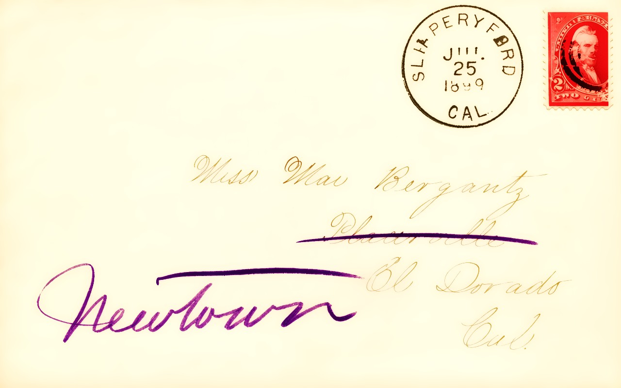
Phil Veerkamp recently shared an image of a letter from his grandfather, Louis Veerkamp, to Mai Bergantz, the woman who would become his grandmother. The letter bears a striking postmark:
“SLIPPERYFORD — JULY 25, 1899.”
That single postmark places the correspondence in a very specific chapter of El Dorado County history — after the community’s official postal name had been compressed from Slippery Ford to Slipperyford, but 12 years before the name Kyburz appeared.
The road to Kyburz began at Slippery Ford
The Slippery Ford Post Office was established Nov. 21, 1861, with Powell Crosley serving as the first postmaster. Historical accounts say the name came from a large, smooth rock that made a crossing of the South Fork of the American River particularly treacherous.
The surrounding canyon was part of an important transportation route through the Sierra.
Nearby stood the Slippery Ford House, which served as a stopping place for stages and freighters traveling through the mountains. Travelers approaching the river had to contend with terrain that could be hazardous for both animals and wagons.
The post office name changed in 1896, when “Slippery Ford” officially became the single word Slipperyford.
That is the name appearing on Veerkamp’s 1899 family letter.
Fifteen years later, the name changed again.
On Jan. 13, 1911, the Slipperyford Post Office became Kyburz, honoring pioneer Samuel E. Kyburz. His son, Albert Kyburz, was the postmaster at the time.
In other words, a letter addressed from Slipperyford in 1899 was not coming from some forgotten settlement somewhere else. It was coming from the community that El Dorado County residents know today as Kyburz.
Then there is Strawberry
This is where the historical trail becomes more complicated.
A common interpretation of old maps places “Echo” near the Strawberry area and can give the impression that Strawberry itself was the Echo post office.
But postal records tell a more complicated story.
The historical list A Century of California Post Offices, 1849-1955 records an Echo Post Office established Aug. 16, 1886. That office continued until Dec. 15, 1910, when service was transferred to Meyers. A subsequent Echo listing shows service beginning again Jan. 28, 1911, before being transferred to Kyburz in 1913.
That chronology matters because it demonstrates that Echo was an actual postal designation, not simply a cartographic label.
At the same time, the historic transportation landscape around Strawberry was considerably broader than the boundaries of today’s communities.
Strawberry was an important resort and stage-stop area along the old route through the American River canyon. The historic road passed through places that have been bypassed or substantially altered by modern U.S. 50, including Baker’s Place, Devil’s Gap and the Slippery Ford House.
Why old maps can be misleading
The confusion becomes understandable when looking at the age and scale of the maps themselves.
The U.S. Geological Survey’s Pyramid Peak quadrangle dates to the late 19th century. The related USGS Pyramid Peak material encompasses a huge section of the Sierra, including portions of El Dorado County and the high country around Echo and Pyramid Peak. The original quadrangle covered roughly 931 square miles.
The USGS material also documents the geography around Echo, Strawberry Creek, Lover’s Leap and the South Fork of the American River as part of a connected mountain landscape rather than the neatly separated communities modern residents see today.
That is an important distinction.
A label appearing near another geographic feature on a 19th-century map does not necessarily mean the two places were the same community, post-office location or settlement.
Maps of the period were working documents created at scales very different from today’s digital maps. A place name could identify a valley, station, road crossing, post office, resort or geographic feature. Sometimes those names overlapped geographically without being interchangeable.
The 1899 letter provides a remarkable timestamp
That makes the Veerkamp letter particularly valuable.
The July 25, 1899, “SLIPPERYFORD” postmark captures the community during the 15-year period when the official postal name was written as one word.
It also provides a human connection to a place-name transition that otherwise appears only as a line in a historical record:
Slippery Ford — 1861
Slipperyford — 1896
Kyburz — 1911
The letter was written in the middle of that transition — close enough to the Gold Rush-era transportation network that “Slippery Ford” still carried the identity of the community, but only 12 years before Albert Kyburz changed the name to honor his father.
For the Veerkamp family, however, the postmark means more than geography.
It marks the beginning of a family story.
Louis Veerkamp was writing to Mai Bergantz, who would become his wife and the grandmother of Phil Veerkamp. A piece of mail that traveled through an obscure Sierra post office more than 125 years ago has therefore survived not merely as postal history, but as a personal artifact tied to a family relationship.
The lesson in the old names
Today’s traveler sees Kyburz, Strawberry and Echo as recognizable places along the U.S. 50 corridor.
The 19th-century traveler saw something different: a chain of river crossings, stage stations, resorts, mountain trails, postal stops and high-country routes.
The names changed.
The roads changed.
The transportation system changed.
But the geography remained.
The South Fork of the American River still cuts through the canyon. Lover’s Leap still towers above the river. Strawberry remains part of the historic corridor toward Echo Summit, and Kyburz still occupies the landscape once known to mail carriers as Slippery Ford.
And somewhere in that landscape, preserved on an old envelope, are two names — Louis and Mai — connected by a letter carrying a postmark that reads like a forgotten piece of El Dorado County itself:
SLIPPERYFORD.
Editor’s historical note: The available postal-history sources support the Slippery Ford-to-Slipperyford-to-Kyburz sequence. They do not substantiate an 1865 “Strawberry Valley Post Office” in El Dorado County. The Echo Post Office is documented beginning in 1886. Further examination of the original USGS Pyramid Peak sheet and surviving postal records could help pinpoint the precise historical location of the Echo office and explain how the map-label confusion developed.