Smith Flat’s Living Memory: A Bicentennial Recounting From Joe Kola
During the county bicentennial oral history project I Remember, organized through a local chamber-led effort, longtime Smith Flat resident Joe Kola offered a firsthand family recounting of pioneer-era El Dorado County — tracing homesteads, mines, wagon routes and the evolution of the Smith Flat House from Gold Rush way station to historic landmark.
Speaking from his Smith Flat home, Kola described a multigenerational foothill lineage rooted in farming, winemaking, freight travel and mining infrastructure. His testimony connects present-day landmarks — including the Böeger Winery property area, Smith Flat Road and the old Highway 50 alignment — to 19th-century settlement patterns and transportation networks that shaped the Placerville corridor.
Homesteads, Wine and Early Family Roots
Kola reported that his maternal grandmother, surnamed Lombardo (spelled L-O-M-V-A-R-D-O in family records), was born on what later became the Bogar Winery site. The Lombardo family homesteaded and farmed there, producing wine on a small scale alongside agriculture — a common diversified survival strategy among foothill settlers.
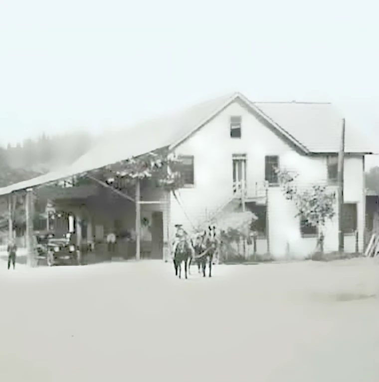
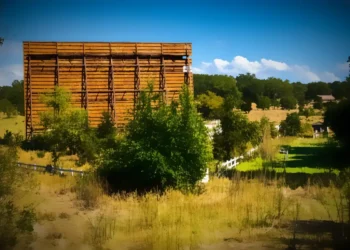
On another branch, the Fasotti (rendered in the interview as F-O-S-A-T-I) family acquired and expanded the Smith Flat House property after its early construction in the 1850s. Kola noted that portions of the structure date to about 1854, consistent with its recognized Gold Rush–era origin as a freighting stop.
Smith Flat House and the Freight Road Era
Before modern Highway 50 was built in its present alignment in the early 20th century, traffic moved directly through Smith Flat and Placerville along what had been part of the Lincoln Highway corridor. Kola explained that the Smith Flat House functioned first as a food and service stop for freight teams hauling goods toward Nevada mining districts, including Virginia City.
“It was a way station for the teams hauling to Virginia City,” Kola said. “Mostly food at that time.”
Later additions expanded the building with wings and rooms, converting it from a simple rectangular stop into a larger hospitality structure. Family records preserved deeds, water rights and photographs documenting those expansions.
Toll Roads, Post Offices and Moving Politics
The Smith Flat corridor once included a toll house near today’s rail crossing area by Fiedler Park. Freight and stage routes required toll collection — another reminder that early transportation infrastructure was privately financed and operated.
Kola also described how the Smith Flat post office shifted locations depending on federal political administrations.
“My grandfather was a Republican and the people down the street were Democrats,” he said. “So it moved as the administration changed — moved up and down the street.”
Family-held postal records reportedly document each relocation and postmaster change — a rare continuous local archive.
Mines, Water Power and Tunnel Engineering
Mining activity dominated the Smith Flat area through the late 19th century and again during the Great Depression. Kola recalled the Carpenter Mine near present Airport Road and the Benfelt Mine near today’s Smith Flat overcrossing area.
Operations used varied technologies — including water wheels, Cornish pumps and improvised ventilation systems. One small operator used a boiler and tall smokestack to create draft ventilation through an incline shaft.
“He built a big roaring fire … and the draft would pull out of the bottom of the mine to clear the air,”
Kola recalled.
Water delivery systems were equally inventive. A mine tunnel on family property still supplied water to the Smith Flat House under a historic $25 gold payment agreement — never revoked — granting continued water rights.
Blacksmiths, Wagons and the Creighton Shop
Kola described the Creighton blacksmith and wagon works in Smith Flat, where carriages and wagon gear were built and repaired. A large granite tire-shrinking stone — used to heat and contract iron rims onto wooden wheels — remained visible into the 20th century.
Water power from pipelines fed shop operations, and nearby households sometimes drew their own domestic water from those same lines before municipal systems arrived.
Electricity and Modernization
Electric power reached Smith Flat around 1924, Kola said, largely because mining operations justified the infrastructure investment.
“The reason we got it then … the Carpenter Mine got the electricity through here. People didn’t count, but the mining did,”
he said.
Road paving followed in segments. Placerville streets were paved early, but stretches through Smith Flat remained gravel until later highway upgrades in the 1930s.
Logging Camps and Regional Industry
Beyond Smith Flat, Kola grew up around Michigan-California Lumber Co. logging camps near present-day Stumpy Meadows and other high-country sites. He recalled wood-burning logging locomotives, cable crossings over the American River and seasonal fire risks — part of the industrial backbone that paralleled mining in sustaining the county economy.
Why These Oral Histories Matter
The bicentennial interview series captured details often missing from official records — daily practices, mechanical improvisations, business customs and family continuity tied to specific properties.
Kola’s recollections link still-standing structures — including the Smith Flat House and Creighton-era buildings — to their working roles in freight, mining, agriculture and travel. Such firsthand testimony provides texture to El Dorado County history beyond dates and deeds.
Hear the tape recording here: https://californiarevealed.org/do/619f91af-647a-4a7e-9c3d-be3789552ef4
Also See:
Smith Flat House in Placerville closed its dining room
Deep Blue Lead talk and Gallery Reception


