Cris Alarcon, InEDC Writer. Feb 9, 2026)
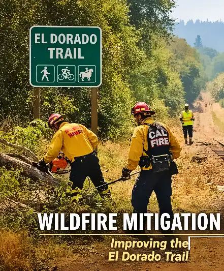
EL DORADO COUNTY, Calif. — CAL FIRE’s Amador–El Dorado Unit (AEU), working with the County of El Dorado and Friends of the El Dorado Trail, has launched a vegetation management and safety improvement project along the unpaved section of the El Dorado Trail, targeting wildfire risk and trail accessibility across a 25-mile stretch.

Firefighter crews from AEU’s Ponderosa Fire Center began work in February along the natural-surface segment of the trail running west from the El Dorado Train Station to the county line. The corridor follows a historic railroad alignment and passes through mixed terrain in the Wildland-Urban Interface, where developed areas meet fire-prone vegetation.
Project operations include thinning brush and small trees roughly 20 feet on each side of the trail, removing downed timber, and clearing weeds and ladder fuels. Crews are using a specialized rail-mounted chipper system to process cut vegetation efficiently while limiting disturbance to the trail bed and surrounding corridor. Work is expected to continue weekly through February, according to CAL FIRE AEU.
“The El Dorado Trail is both a valued community recreation asset and an important fuel break that runs for miles through high fire-risk areas,”
said Battalion Chief Mark Abeloe of CAL FIRE AEU’s Ponderosa Fire Center.
“This project reflects collaboration to improve community safety, protect natural resources, and support long-term wildfire resilience.”
Officials said the effort marks the first time CAL FIRE AEU crews have conducted organized vegetation management on the unpaved portion of the trail, though similar partnership work has taken place for years along paved segments.
County parks officials say the project brings multiple agencies and nonprofit partners together around shared risk-reduction goals.
“El Dorado County’s Parks and Trails Division — in partnership with CAL FIRE AEU, Friends of the El Dorado Trail, and the El Dorado Western Railway Foundation — are proud to join forces to clear hazardous trees and reduce fuel loads along the Natural Trail portion of the El Dorado Trail,”
said Zachary Perras, El Dorado County parks manager.
“This collaborative effort not only strengthens wildfire resilience and improves safety but also reflects our shared commitment to caring for this treasured corridor.”
The El Dorado Trail is a planned multimodal transportation and recreation corridor intended to span the full length of El Dorado County, from the western boundary to the Lake Tahoe Basin. At present, the trail extends about 37 miles from the county line to Camino, with paved sections between El Dorado and Camino and natural-surface stretches beyond.
County officials say the fuel reduction work is designed to protect nearby communities while preserving trail access for hikers, cyclists, equestrians, and rail history enthusiasts.
For public background and maps of the paved trail sections, the county provides trail planning documents and handouts through its Parks and Trails Division.


