El Dorado County (Feb 26, 2024) –
Current Conditions in Diamond Springs [Elev: 905.0 ft.]
Temperature: 43°F
Sky: Mostly Cloudy
Winds: Southwest at 7 mph
Tonight’s Forecast – February 26, 2024
Mostly cloudy skies with a chance of rain showers in the evening, transitioning to a slight chance after midnight. Lows ranging from 35 to 43°F. Expect prevailing southwest winds up to 10 mph.
Tuesday – February 27, 2024
Starting off mostly cloudy in the morning, clearing later. Highs between 52 and 60°F. Light winds becoming northwest up to 10 mph in the afternoon.
Tuesday Night
Mostly clear skies with lows of 37 to 43°F. Prevailing northwest winds up to 10 mph, becoming light later in the evening.
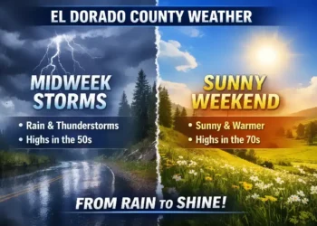
Wednesday – February 28, 2024
Sunny conditions with highs ranging from 54 to 64°F. Light winds in the morning becoming southwest up to 10 mph in the afternoon.
Wednesday Night
Mostly clear with lows from 39 to 45°F. Prevailing south winds up to 10 mph, shifting to the southeast after midnight.
Thursday – February 29, 2024
Mostly cloudy with a chance of rain showers. Highs between 45 and 60°F.
Thursday Night
Rain showers expected with breezy conditions. Lows ranging from 37 to 49°F.
Friday – March 1, 2024
Rain showers continuing, turning windy. Highs between 40 and 54°F.
Friday Night
Rain showers persisting with blowing snow, windy, and colder conditions. Visibility may drop to one-quarter mile or less at times. Lows from 31 to 41°F.
Saturday – March 2, 2024
Rain and snow showers anticipated. Light snow accumulations possible. Highs between 35 and 49°F.
Saturday Night
Mostly cloudy with rain and snow showers likely. Colder conditions with moderate snow accumulations possible. Lows from 26 to 36°F.
Sunday – March 3, 2024
Mostly cloudy with a chance of rain and snow showers. Highs between 37 and 51°F.
Sunday Night & Monday
Mostly clear conditions with widespread frost. Lows ranging from 24 to 34°F. Highs between 43 and 55°F.
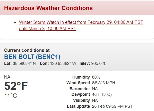
Winter Storm Watch – February 29, 04:00 AM PST until March 3, 10:00 AM PST
Locations Affected: West Slope Northern Sierra Nevada, Northeast Foothills, Motherlode, and Western Plumas County/Lassen Park, including Interstate 80 and US Highway 50.
Potential Hazards: Extremely heavy snow and strong winds may lead to whiteout conditions at times. Total snow accumulations of 5 to 9 feet possible above 5000 feet, with 1 to 4 feet above 3000 feet and lighter accumulations down to 2000 feet. Winds could gust as high as 65 mph.
Timing: From early Thursday through Sunday morning.
Impacts: Travel could be very difficult to impossible, with widespread blowing snow reducing visibility. Hazardous conditions may affect commutes, and strong winds could cause tree damage and power outages.
Additional Details: Snow levels initially around 5000 to 6000 feet, dropping to 2000 feet by the weekend. Heaviest snow expected on Friday.


