????️ National Weather Service El Dorado County CA – January 5, 2024 ????️
Alert: WINTER STORM WARNING in effect from 4 AM Saturday to 4 AM PST Sunday.


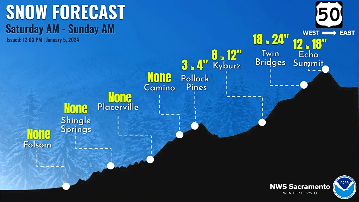
Locations: Highway 50 over Echo Summit and Highway 88 over Carson Pass.
What to Expect:
- Snowfall: Heavy snow with total accumulations of 1 to 2 feet, possibly more on high peaks.
- Winds: Gusting up to 55 mph, contributing to challenging travel conditions.
- Impacts: Travel may become extremely difficult, with delays, chain controls, and snow-covered roads. Poor visibility, with near-whiteout conditions at times. Gusty winds could lead to falling tree branches.
Timeline:
- Start: 4 AM Saturday
- End: 4 AM PST Sunday
Additional Details:
- Snow Levels: 2,000 to 3,000 feet on Saturday, dropping as low as 1,000 feet on Sunday morning.
- Snow Rates: Up to 2 inches per hour. Elevations below 2,000 feet may see minimal accumulation.
- Caution: Hazardous conditions will impact weekend travel plans.
Precautions:
- If you must travel, carry extra supplies in your vehicle: flashlight, food, and water.
- Stay updated on road conditions: Call 800-427-7623 (ROAD) or check quickmap.dot.ca.gov before traveling.
Pollock Pines Extended Forecast – Elev: 4613.0ft
Detailed Forecast:
Tonight
- Increasing clouds, low around 32.
- East-southeast wind 3 to 6 mph.
Saturday
- Snow showers after 10 am, heavy at times.
- High near 38. South-southwest wind 12 to 17 mph, gusting up to 25 mph.
- Precipitation chance: 100%. New snow accumulation: 1 to 3 inches.
Saturday Night
- Snow showers before 10 pm, low around 20.
- Southwest wind becoming east-northeast after midnight.
- Precipitation chance: 90%. New snow accumulation: around an inch.
Sunday
- Widespread frost before 3 pm, increasing clouds.
- High near 37. East-northeast wind 7 mph, becoming north-northwest.
Sunday Night
- Widespread frost, mostly clear, low around 24.
- East-northeast wind 6 to 8 mph.
Monday
- Areas of frost after 5 pm, mostly sunny, high near 40.
Monday Night
- Widespread frost before midnight, then after 2 am.
- Partly cloudy, low around 29.
Tuesday
- Chance of showers after 10 am, partly sunny, high near 40.
Tuesday Night
- Chance of rain and snow showers before 10 pm, mostly cloudy, low around 30.
Wednesday
- Snow showers likely after 10 am, partly sunny, high near 34.
Wednesday Night
- Snow showers likely, mostly cloudy, low around 24.
Thursday
- Chance of snow showers, partly sunny, high near 34.
Thursday Night
- Chance of heavy snow showers, mostly cloudy, low around 27.
Friday
- Chance of heavy snow showers, partly sunny, high near 36.
Source:
NOAA


