
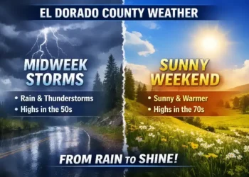
PLACERVILLE, Calif. — A persistent wet weather pattern will move into El Dorado County this weekend, bringing steady rain showers from Friday through at least Tuesday, according to the latest forecast from the National Weather Service and multiple forecast models tailored for the Mother Lode region.
Conditions will begin to deteriorate Friday when mostly cloudy skies give way to increasing rain chances in the morning and afternoon, with a 70% to 90% chance of precipitation that is expected to persist overnight. Showers continue through Saturday and Sunday, with the potential for thunderstorms Sunday afternoon, particularly in the foothills and lower elevations around the Motherlode community at approximately 905 feet elevation.
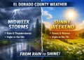

By Monday through Tuesday, rain showers will likely remain, though the intensity may ease slightly compared with the peak weekend activity. Highs are forecast in the low to mid-50s, while overnight lows dip into the upper 40s to lower 50s, typical for mid-December patterns in the Sierra foothills.
“We’re looking at a wet stretch that’s more persistent than the usual isolated shower pattern,” said a National Weather Service meteorologist in Sacramento. “Residents should plan for wet roads, reduced visibility at times, and be ready for slippery conditions, especially if heading out during peak rainfall late Saturday into Sunday.” (Forecast Office — statement adapted from forecast data)
Detailed Forecast Highlights
Tonight:
-
Mostly cloudy, becoming partly cloudy with a slight chance of rain showers overnight and possible locally dense fog.
Thursday:
-
Fog in the morning, partly to mostly cloudy with slight rain chances in the afternoon.
Thursday Night:
-
Increasing clouds, with rain chance elevating toward midnight.
Friday:
-
Rain likely, especially in the afternoon with up to a 70–90% chance of precipitation.
Friday Night — Sunday:
-
Steady rain showers expected, with Saturday and Sunday showing strong rain likelihood and possible thunderstorms Sunday.
Monday — Tuesday:
-
Continued rain showers likely with cooler temperatures and lingering precipitation chances.
Local Impact and Preparations
With steady rain expected for multiple days, residents should anticipate wet and potentially slick roads, reduced visibility in foggy conditions, and localized ponding in low-lying areas. Motorists are advised to reduce speeds during downpours and allow extra travel time. Outdoor events and activities should be rescheduled or planned with rain preparations in mind.
For the most up-to-date forecast and any hazardous weather statements, visit the National Weather Service Sacramento website.


