
By Cris Alarcon, InEDC Writer. (Nov 2, 2025)
Rain and Cooler Temps Expected Midweek in El Dorado County
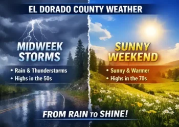
El Dorado County, CA — November 2, 2025 | After a warm and sunny start to the week, residents in El Dorado County’s Motherlode region should prepare for a shift toward cooler temperatures and wet weather by midweek. The National Weather Service (NWS) forecasts a developing Pacific storm system that will move inland late Tuesday night, bringing the first widespread rainfall in weeks.


At an elevation of roughly 905 feet, Monday will stay sunny with highs between 66 and 76 degrees, offering ideal conditions for outdoor activities. Winds will remain light, becoming southerly in the afternoon. Overnight, skies will stay clear with lows dipping into the upper 40s to mid-50s.
By Tuesday, expect partly cloudy skies with a slight chance of morning showers, followed by some afternoon clearing. Temperatures will cool slightly, with highs ranging from 62 to 74 degrees. Rain chances increase again late Tuesday night as a new weather front approaches from the Pacific.
Wednesday marks the main event, with steady rain showers and possible afternoon thunderstorms. Daytime highs are expected between 52 and 64 degrees, with lows in the mid-40s to low 50s overnight. The NWS warns of
“localized ponding of water in low-lying areas and slick road conditions during the morning commute.”
The system is forecast to move out quickly, leaving mostly clear skies by Thursday, with pleasant highs in the upper 50s to upper 60s. Another weak disturbance could bring a slight chance of rain Friday, before dry and mild conditions return for the weekend.
“We’re finally seeing a shift toward a more active fall pattern,” “This is a typical November setup — sunshine early in the week followed by a short, wet system and cooler air behind it.”
said NWS Sacramento meteorologist Brooke Bingaman.
Residents are encouraged to clear gutters, check drainage around their properties, and prepare for potentially slick roads by midweek.


