
El Dorado County, CA (Feb 6, 2025) – Elev: 905.0 ft.
Current Conditions: As of 4:36 PM PST, El Dorado County is experiencing cloudy skies with temperatures around 50°F (10°C). A Wind Advisory is currently in effect from 4:00 PM this afternoon until 1:00 AM PST on Friday, February 7. Residents should anticipate south winds ranging from 10 to 20 mph, with potential gusts up to 45 mph.
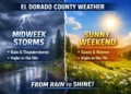

Tonight (Thursday, February 6): Expect rain showers with a slight chance of thunderstorms early in the evening, transitioning to a chance of rain showers later in the night. Patchy fog is likely to develop and persist through the night. Temperatures will drop to lows between 33°F and 43°F. Prevailing south winds will blow at 10 to 20 mph, with gusts reaching up to 45 mph.
Friday, February 7: The day will be mostly cloudy, with patchy morning fog. There is a chance of rain showers and a slight possibility of thunderstorms in the morning, followed by a continued chance of rain showers in the afternoon. High temperatures are expected to range between 42°F and 54°F. Prevailing southwest winds will be up to 10 mph, with morning gusts up to 30 mph.
Friday Night: Conditions will clear, becoming mostly clear with areas of frost developing after midnight. It will be colder, with lows between 27°F and 35°F. Light winds are anticipated.
Saturday, February 8: Widespread morning frost is expected under sunny skies. High temperatures will range from 46°F to 54°F. Light winds will become northwest up to 10 mph in the afternoon.
Saturday Night: The night will be clear, with areas of frost forming. Lows will be between 27°F and 33°F, accompanied by light winds.
Sunday, February 9: Sunny conditions are forecasted, with widespread frost in the morning. Highs will range from 47°F to 55°F.
Sunday Night: Expect clear skies with areas of frost. Low temperatures will be between 26°F and 34°F.
Monday, February 10: Sunny skies are anticipated, with widespread morning frost. Highs will be between 45°F and 53°F.
Monday Night: The night will be mostly clear, with areas of frost developing. Lows are expected to be between 26°F and 34°F.
Tuesday, February 11: Partly cloudy skies with a slight chance of rain showers are forecasted. Widespread frost is expected in the morning. High temperatures will range from 42°F to 50°F.
Tuesday Night: The night will be mostly cloudy, with a chance of rain and snow showers. Lows will be between 25°F and 33°F.
Wednesday, February 12: Mostly cloudy conditions with rain and snow showers likely. Highs are expected to be between 42°F and 50°F.
Wednesday Night and Thursday, February 13: Rain showers are anticipated during this period. Low temperatures will range from 31°F to 39°F, with highs between 41°F and 51°F.
Safety Advisory: Due to the Wind Advisory in effect, residents are urged to secure loose outdoor objects and exercise caution while driving, especially in high-profile vehicles. The combination of gusty winds and moist soils increases the risk of downed trees and power lines, potentially leading to power outages.
For the most current updates, please monitor local weather stations and the National Weather Service.


