The question behind the name
For El Dorado County residents who know the Shingle Springs Rancheria primarily because of Red Hawk Casino, the story of the reservation begins nearly a century before gaming entered the picture.
It begins along the Sacramento River.
It also begins with a federal government program designed to address a grim reality confronting California Indians in the decades following the Gold Rush: many Native families had been dispossessed of their traditional lands and were living without a permanent land base.
The federal government eventually purchased dozens of small parcels for California Indians. Federal court records describe the program as an effort prompted by investigations into the “landless, homeless or penurious state” of many California Indians.
The Shingle Springs Rancheria was one of those acquisitions.
From Verona to El Dorado County
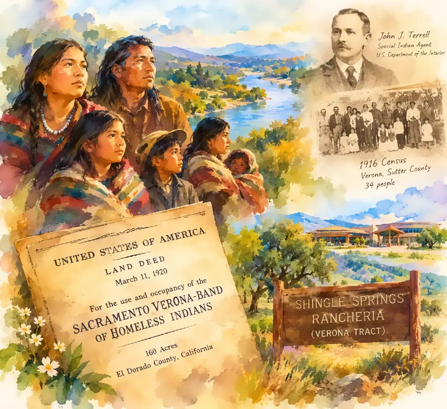
One of the most important names in the story is John J. Terrell, an inspector and special Indian agent for the Department of the Interior.
According to a 2003 National Indian Gaming Commission legal opinion examining the history and legal status of the Shingle Springs Rancheria, Terrell spent approximately four years working to acquire land for what federal records called the Sacramento-Verona Indians. His assignment involved finding a permanent home for landless Indians in the Sacramento area.
A 1916 census document preserved in the historical record provides a snapshot of the people Terrell’s work concerned.
The document is titled “Census of the Indians at and near Verona in Sutter County, California; also 15 living in Sacramento.” It identifies families at Verona and in Sacramento, including the Murray, Adams, Bull and Cook families. The document ultimately records 34 people.
The census is particularly significant because it illustrates that the population later associated with the Sacramento-Verona Band was not simply an abstract federal designation. Government agents were identifying actual families, their relationships and where they lived.
The record also reveals something that would become important in subsequent federal correspondence: the group included people of Native Hawaiian ancestry who had married California Indians.
In a December 1916 correspondence discussed by the NIGC, Terrell defended the inclusion of several Hawaiians in his census. He explained that they were married to Native California women and argued that the families would likely remain together if land were acquired for them.
That issue demonstrates why the historical record cannot be reduced to a simple modern racial or tribal label. The federal government was dealing with interconnected families whose ancestry included California Indians and Native Hawaiians.
Congress had already created the land-purchase program
Terrell was not operating without congressional authority.
In 1906, Congress appropriated $100,000 for the purchase of suitable parcels for California Indians, including Indians who were not living on reservations. The statute authorized the Interior Department to acquire land, water and water rights for their use. Subsequent appropriations expanded the program.
Federal court decisions later described the resulting parcels as rancherias — small Indian reservations or communities created through government land purchases.
The important distinction is that the 1906 legislation did not itself name the Sacramento-Verona Band. Rather, it created the broader federal program under which land could be acquired.
The specific connection between the Sacramento-Verona Indians and the Shingle Springs property appears in the administrative record and, most decisively, in the deed itself.
The 1920 deed is the crucial document
On March 11, 1920, the United States acquired a 160-acre parcel in El Dorado County from the estate of Walter J. Meldrum.
The purchase price was $1,400.
The legal description identifies the property as the northwest quarter of Section 29, Township 10 North, Range 10 East, Mount Diablo Base and Meridian.
But the most important language is what followed.
The deed conveyed the property to the United States:
“for the use and occupancy of the Sacramento Verona-Band of Homeless Indians.”
That language is reproduced in the National Indian Gaming Commission’s legal opinion concerning the Shingle Springs Rancheria.
This is considerably stronger evidence than simply finding a later historical account saying that the rancheria was intended for Sacramento-area Indians.
It is the actual language attached to the federal government’s acquisition of the land.
The paper trail shows a deliberate effort
The NIGC record fills in an important part of the story that is sometimes lost in modern arguments over tribal identity.
In 1918, Meldrum apparently sought to withdraw from the proposed purchase. The Indian Service responded by asking whether he intended to honor the purchase agreement.
After Meldrum died, federal officials instructed his estate that the deed should convey the property to the United States for the use and occupancy of the Sacramento-Verona Band of Landless Indians of California.
The estate ultimately submitted the deed and abstract in April 1920.
The NIGC later characterized the acquisition as the culmination of several years of federal efforts to obtain land for the Sacramento-Verona Indians.
It concluded that the history of the acquisition showed a specific purpose: providing a place to live for Sacramento-area Indians who lacked a permanent land base.
So why “Shingle Springs”?
The name came later.
The 1920 deed did not call the people the Shingle Springs Band of Miwok Indians.
It called them the Sacramento Verona-Band of Homeless Indians.
Federal records examined by the NIGC show the group’s name evolving over the following decades. By the 1970s, members were using terms such as “Shingle Springs Rancheria (Verona Tract)” in identifying themselves.
The band’s 1976 Articles of Association identified membership through the 1916 census and descendants of the people listed there. The NIGC opinion states plainly that the people who descended from the Sacramento-Verona Band later identified themselves as the Shingle Springs Band.
That provides an important answer to a question that frequently gets muddled in contemporary debate:
“Sacramento-Verona Band” and “Shingle Springs Band of Miwok Indians” are not two names that appeared simultaneously on the 1920 deed. They represent names used at different points in the group’s documented history.
What the federal government says today
The federal government currently recognizes the Shingle Springs Band of Miwok Indians, Shingle Springs Rancheria (Verona Tract), California as a federally recognized Indian tribe. The Bureau of Indian Affairs continues to use that designation in its official records, including current federal listings and tribal-state gaming compact records.
The 2020 tribal-state compact provides an unusually direct modern description of the historical connection. It states that the tribe’s forebears were settled on a federally owned parcel in El Dorado County that became known as the Shingle Springs Rancheria (Verona Tract). It further states that federal agents acquired the 160 acres in 1920 to provide a home base for homeless Indians emanating from El Dorado, Sutter and Sacramento counties, then generally known as the Sacramento-Verona Band of Homeless Indians.
That language is significant because it comes from a formal compact between the State of California and a federally recognized tribal government, rather than from a modern newspaper account or social-media argument.
The rancheria was not simply a private land purchase
There is another important legal distinction.
The United States acquired the property. The 1920 deed did not convey the land directly to individual tribal members.
The NIGC later determined that the rancheria was a reservation and that the federal government had historically treated the land as trust property for the benefit of the tribe. The agency noted that the Interior Department maintained its fiduciary relationship to the Indians associated with the rancheria even though the original deed did not use the modern phrase “held in trust.”
In 2003, the NIGC concluded that the Shingle Springs Rancheria constituted Indian lands for purposes of the Indian Gaming Regulatory Act and that the Shingle Springs Band exercised governmental jurisdiction over it.
That legal conclusion later became important when El Dorado County and other parties challenged the proposed casino development.
In El Dorado County v. Caltrans, a 2005 California Court of Appeal decision, the court described the Shingle Springs Rancheria as a federally recognized reservation held in trust by the Bureau of Indian Affairs for the tribe’s benefit.
But the historical record is contested
A documentary treatment of this subject should not omit the other side of the historical dispute.
People who challenge the current tribal government’s historical claim to the rancheria have argued that Native people indigenous to the Shingle Springs and El Dorado County area were distinct from the Sacramento-Verona group. Some have further argued that the federal government acquired separate land for El Dorado County Indians and that descendants of those families were subsequently excluded from the modern tribal government.
Those claims appear in federal court pleadings and other advocacy materials. For example, a 2009 federal filing by Cesar Caballero alleged that an 80-acre “Dorado Tract” had been acquired for El Dorado County Indians and that the 160-acre “Verona Tract” had been acquired for the Sacramento-Verona Band.
Those allegations should not, however, be presented as established fact merely because they appear in a court filing. They represent one side of a long-running dispute.
The federal government’s subsequent administrative and legal record has recognized the Shingle Springs Band as the tribe associated with the rancheria.
The 2003 NIGC opinion is particularly important because it examined the historical land documents, BIA correspondence and the evolution of the band’s name before reaching its conclusion. It specifically stated:
“The history of the acquisition of land for the Sacramento-Verona Band is, therefore, the history of the Shingle Springs Rancheria.”
What the documents actually establish
For a documentary intended for an El Dorado County audience, the most defensible conclusion is narrower — and stronger — than some of the claims circulating on social media.
The documentary record establishes that:
- Federal officials were operating a California land-purchase program for landless Indians.
- John J. Terrell spent years working to obtain land for the Sacramento-Verona Indians.
- A 1916 federal census documented families living at and near Verona in Sutter County and others living in Sacramento, totaling 34 people.
- The United States acquired 160 acres in El Dorado County on March 11, 1920, for $1,400.
- The deed explicitly stated that the property was for the “use and occupancy of the Sacramento Verona-Band of Homeless Indians.”
- The federal government subsequently treated the property as the land base associated with the group that became known as the Shingle Springs Band of Miwok Indians.
- The present-day Shingle Springs Band of Miwok Indians remains federally recognized under the name “Shingle Springs Band of Miwok Indians, Shingle Springs Rancheria (Verona Tract), California.”
What those documents do not automatically establish is that every Native American family historically living in the Shingle Springs area was a member of the Sacramento-Verona Band, nor do they by themselves resolve modern questions about tribal enrollment, ancestry or competing claims to tribal membership.
Those are separate historical and legal questions.
The significance for El Dorado County
The Shingle Springs Rancheria is therefore not a story that begins with a casino.
Its documented federal history reaches back to an era when Native families in California had lost much of their land and were living without secure homes. The federal government created a land-acquisition program, an Indian agent investigated individual communities, families were documented, and officials eventually purchased a 160-acre parcel in the foothills.
The deed put the purpose in unusually plain legal language.
The United States bought the land for the Sacramento Verona-Band of Homeless Indians.
A century later, that same parcel is a federally recognized reservation known as the Shingle Springs Rancheria (Verona Tract) and is governed by the Shingle Springs Band of Miwok Indians.
For anyone trying to understand the history behind one of El Dorado County’s most consequential pieces of property, the 1920 deed is the place to start.
It is not a social-media interpretation.
It is the government’s title record.
Primary documents and records for further documentary research
- National Indian Gaming Commission, “Shingle Springs Indian Lands Opinion,” Nov. 25, 2003. This is one of the most useful compilations of the deed, BIA correspondence, 1916 census references and subsequent history.
- 1920 deed from the Estate of Walter J. Meldrum to the United States. The deed contains the critical “use and occupancy” language.
- 2020 Tribal-State Compact between California and the Shingle Springs Band. Its preamble describes the 1920 acquisition and the Sacramento-Verona Band.
- Bureau of Indian Affairs current tribal records. The federal government presently lists the Shingle Springs Band of Miwok Indians, Shingle Springs Rancheria (Verona Tract), California, among federally recognized tribes.
- El Dorado County v. Caltrans, California Court of Appeal, 2005. The published decision provides important legal background concerning the rancheria’s reservation and trust status.
ADDENDUM
-
- The Recognized Tribe: The modern, federally recognized Shingle Springs Band of Miwok Indians descends from the Sacramento-Verona Band of Homeless Indians. This group was formally placed on the Shingle Springs Rancheria parcel by the federal government in the early 20th century.
- Caballero’s Claims: According to historical arguments presented by his supporters, Caballero claims descent from the El Dorado Tribe (or El Dorado Rancheria Miwok). This distinct local group lost its federal recognition in the mid-1900s under federal termination policies. While the BIA has verified that Caballero possesses Miwok ancestry, federal entities note that his ancestral group is legally separate from the band that holds the federal rights to the Shingle Springs name and reservation.
-
- Permanent Injunction: The federally recognized tribe successfully sued Caballero for trademark and trade name infringement. The U.S. District Court issued a permanent injunction barring him from using the tribe’s name, marks, or identifying himself as an official representative.
- Dismissal of Counter-suits: Federal judges dismissed multiple counter-lawsuits filed by Caballero, affirming that the court system cannot overturn or alter federal tribal recognition.
- Criminal Conviction: In 2011, Caballero was convicted in federal court of obstruction of mail after filing fraudulent U.S. Postal Service forms to divert mail intended for the Shingle Springs tribe and their Red Hawk Casino to his own home address. He was later convicted again for failing to surrender for his prison sentence.
-
- Asset Distribution: The law mandated that communal tribal lands be subdivided and distributed to individual adult tribal members as private, taxable property. [1, 2]
- Loss of Trust Status: Once distributed, the land lost its status as protected “Indian Country”. It became subject to local property taxes, state zoning laws, and eventual foreclosure or sale to non-natives.
- Revocation of Recognition: The federal government revoked its official recognition of the tribes. Tribal members were stripped of their eligibility for federal healthcare, education, and housing assistance explicitly designated for Native Americans.
The Impact on the El Dorado Rancheria
-
- The 1964 Amendment: While the initial 1958 act targeted 41 specific rancherias, a 1964 amendment expanded the law to sweep in remaining reservations across California, explicitly naming the El Dorado Rancheria.
- Official Closure Date: Following land surveys and the drafting of a property distribution plan, the U.S. Department of the Interior officially announced the termination of federal supervision over the Miwok Tribe of the El Dorado Rancheria on July 16, 1966.
- The Aftermath: With termination finalized, the El Dorado Miwok ceased to exist as a federally recognized sovereign entity. Their communal land base evaporated into private parcels, and the tribe was omitted from future federal resource allocations.
The Contrast: Why Shingle Springs Survived
The Status of the El Dorado Miwoks Today
Part 1: Allotment Maps & Land Distribution of the El Dorado Rancheria (1966)
- The Distribution Plan Document: Before final termination in 1966, BIA agents drafted a formal “Distribution Plan” mapping the small rancheria parcel. This plan surveyed the acreage and divided the communal asset among the verified adult members of the El Dorado Miwok group residing on or legally tied to the property.
- The Form of Distribution: Rather than issuing individual trust allotments, the federal government issued fee-simple patents (deeds). This completely stripped the land of its protected trust status. The land became private, taxable property.
- Where the Maps and Records are Held: Because these 1966 distribution plans and survey maps are historical Bureau of Indian Affairs administrative files, the vast majority are not digitized online. To view the actual maps, parcel divisions, and names of individuals who received the land patents, researchers must access:
- The National Archives at San Francisco (San Bruno, CA): Holds Record Group 75 (Records of the Bureau of Indian Affairs), specifically the Sacramento Area Office files, which contain the original paper distribution folders, census lists, and survey plat maps for the 1960s California Rancheria closures.
- The El Dorado County Recorder’s Office: Holds the land title transfers and chain-of-title deeds filed when the federal government transferred the parcels into private ownership in July 1966.

Part 2: How U.S. Route 50 Legally Impacted Tribal Boundaries
- The tribe held sovereign rights over its 160 acres, but California property laws prevented them from forcing commercial or heavy traffic through the surrounding private easements.
- The local homeowners and El Dorado County argued that the tribe could not develop its reservation because any increased traffic would violate residential zoning and easement capacities on the local access roads.
- The Encroachment and Environmental Lawsuits: El Dorado County and local resident groups filed multiple federal lawsuits against the BIA and the California Department of Transportation (Caltrans). They challenged the environmental impact reviews of a proposed $30 million custom highway interchange that would connect Route 50 directly to the landlocked reservation.
- The Legal Resolution: Federal courts ultimately ruled in favor of the tribe and the BIA, affirming that the federal government had the authority to approve an intersection connecting a landlocked sovereign reservation to a federal highway. The completion of the Shingle Springs Drive / Red Hawk Parkway interchange legally resolved the decades-long isolation caused by the highway’s original mid-century construction.