
El Dorado County, Calif. — A significant storm system is forecasted to impact El Dorado County, bringing heavy rain, strong winds, and potential thunderstorms over the next several days. Residents are advised to prepare for hazardous weather conditions and stay informed of the latest updates.
Wind Advisory
The National Weather Service has issued a Wind Advisory for the northern and central Sacramento Valley and adjacent foothills, effective from Tuesday evening through Wednesday evening.
South winds are expected to be between 20 to 30 mph, with gusts reaching up to 50 mph. These conditions may result in downed trees and power lines, leading to potential power outages.
Detailed Forecast for El Dorado County
-
Tonight: Mostly clear in the evening, becoming mostly cloudy with a slight chance of rain showers after midnight. Lows between 39 to 47 degrees Fahrenheit. Prevailing southwest winds up to 10 mph in the evening, becoming light thereafter. Gusts may reach up to 25 mph.
-
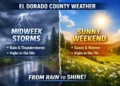
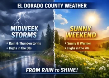
Wednesday: A chance of morning rain showers, with heavy rain anticipated in the afternoon. Patchy fog may develop later in the day. High temperatures will range from 44 to 56 degrees Fahrenheit. Prevailing south winds up to 20 mph, with gusts around 45 mph.
-
Wednesday Night: Heavy rain showers in the evening, transitioning to rain and snow showers after midnight. Temperatures will be colder, with lows between 31 to 41 degrees Fahrenheit. Little to no snow accumulation is expected. Prevailing south winds up to 15 mph, with gusts around 40 mph.
-
Thursday: Rain and snow showers are likely, with a slight chance of thunderstorms in the morning, transitioning to rain showers and a continued slight chance of thunderstorms in the afternoon. Highs will range from 39 to 53 degrees Fahrenheit. No significant snow accumulation is anticipated. Light winds becoming southwest up to 10 mph in the afternoon.
Safety Precautions
Residents are urged to secure outdoor objects that could be blown away or damaged by strong winds. Exercise caution when driving, especially in high-profile vehicles, due to potential wind gusts. Stay updated on weather conditions through reliable sources, such as the National Weather Service and local news outlets.
Looking Ahead
The storm system is expected to persist, with additional rounds of precipitation forecasted through the weekend. This prolonged wet pattern may lead to localized flooding and small landslides, particularly in higher elevations.
Residents should remain vigilant and prepared for changing weather conditions.
For the most current information, visit the National Weather Service’s website or follow their social media channels.
This weather update is based on information available as of March 11, 2025. Weather conditions can change rapidly; always refer to the latest updates from official sources.
Winter Storm Preparedness: El Dorado County Officials Urge Residents to Get Ready
March 11, 2025
EL DORADO COUNTY, Calif. — As a powerful winter storm approaches, county officials are urging residents to take immediate precautions to stay safe and prepared for potentially hazardous conditions. The storm is expected to bring heavy rain, strong winds, and snowfall at higher elevations, increasing the risk of power outages, travel disruptions, and localized flooding.
Preparedness Tips:
Authorities recommend taking the following steps to ensure safety and readiness:
- Power & Heat: Charge essential devices in advance and have backup power sources, such as generators or extra propane for heaters and stoves.
- Fuel Up: Keep vehicles fueled and store extra gasoline, diesel, or propane in case of prolonged outages or travel needs.
- Emergency Kit: Stock up on flashlights, batteries, blankets, and a battery-powered radio for updates during potential power outages.
- Food & Water: Have non-perishable food and at least three days’ worth of water per household member.
- Medical Needs: Ensure you have prescriptions, first aid supplies, and any necessary items for pets or family members with special needs.
- Stay Informed: Sign up for emergency alerts, have a weather radio, and monitor updates from local agencies.
- Travel Caution: Avoid unnecessary travel. If you must drive, check road conditions, carry emergency supplies, and be prepared for delays.
Sandbag Distribution Locations:
For those concerned about potential flooding, sandbags are available at the following locations (bring your own shovel):
- Pollock Pines: DOT Yard, 6700 Pony Express Trail (Open 7 AM – 5 PM)
- Placerville: DOT Yard, 4770 Sand Ridge Road (Open 7 AM – 5 PM)
- Garden Valley: Fire Protection District, 4860 Marshall Road
- El Dorado Hills: Fire Station 85, 1050 Wilson Blvd
- Cameron Park: Fire Station 89, 3200 County Club Drive
- Mosquito: Fire Protection District Station 75, 8801 Rock Creek Road
- South Lake Tahoe: City Fire Station 3, 2101 Lake Tahoe Blvd
Residents can stay informed through local emergency networks and resources, including:
www.ready.edso.org
www.perimetermap.com
With hazardous weather conditions expected to last through the weekend, residents are urged to act now and stay vigilant.


