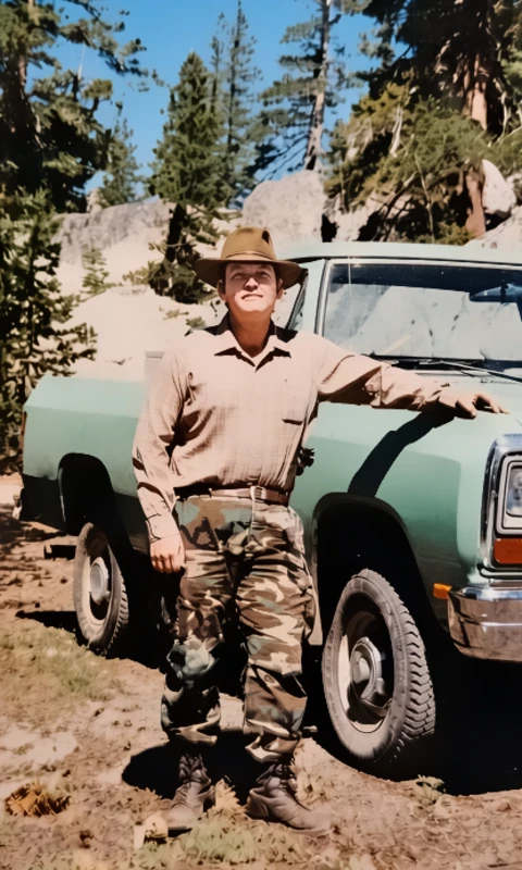
A Sierra Survey Measured in Miles, Mines and Survival
Long before abandoned mine inventories could be displayed on a computer screen, field crews had to find the mines the hard way.
They walked.


They climbed.
They pushed through brush, timber and poison oak, often carrying the equipment needed to document what they found.
For Guy Nixon, that work began in the 1980s as a U.S. Forest Service employee assigned to survey abandoned mines across the Eldorado and Tahoe national forests.
What started as a 12-person operation became something considerably different.
According to Nixon, the first two months were punishing enough that the crew dwindled to two people.
The reasons were familiar to anyone who has spent serious time in the Sierra backcountry: oppressive heat, rattlesnakes and seemingly endless poison oak.
Then there was another hazard.
People.
Nixon recalls encountering hostile illegal drug growers and manufacturers operating in remote forest country. Those encounters added an unpredictable human element to an assignment already demanding enough from the terrain itself.
By the third month, Nixon said, he was the man left doing the work.
And the work was far from finished.
Three years in the forest
Nixon said he continued surveying the Eldorado and Tahoe national forests for approximately three years before completing the assignment.
His account provides a glimpse into an era when locating a mine wasn’t simply a matter of entering coordinates into a digital mapping application.
The Sierra Nevada is a landscape built around mining history. California’s Gold Rush left tens of thousands of abandoned mine sites scattered across the state, including on federal forest lands. Many contain dangerous shafts, tunnels and other physical hazards. Others can pose environmental risks from historic mining practices.
Today, government agencies use sophisticated geographic information systems, databases, GPS technology and standardized field assessments to locate and evaluate abandoned mine features.
The basic problem, however, remains remarkably similar: Someone still has to find what’s out there.
California’s Department of Conservation says its Abandoned Mine Lands Unit inventories historic, inactive and abandoned mines and evaluates physical and chemical hazards. The state’s modern inventory work includes locating mine features with GPS and documenting conditions in the field.
The state’s current data also illustrates how extensive the legacy is. California officials say abandoned mines occur in all 58 counties, with approximately 64% of abandoned mine sites located on federal public lands.
A dangerous legacy beneath the trees
For residents of El Dorado County, abandoned mines are not merely historical curiosities.
They are part of the landscape.
The county sits in the heart of California’s Mother Lode, where generations of prospectors and mining companies searched for gold. Some workings have been incorporated into developed communities, while others remain hidden in forests and backcountry terrain.
An old mine opening can be particularly dangerous because vegetation, erosion and time can conceal the danger.
A horizontal tunnel, known as an adit, can disappear behind brush. A vertical shaft can be hidden beneath seemingly solid ground.
The California Department of Conservation warns that abandoned mines can contain open shafts and adits and that people, pets, livestock and wildlife have been injured or killed at such sites. Some abandoned mines can also contain contaminants including mercury and arsenic or contribute to other water-quality problems.
Modern mine-remediation programs sometimes use fences, backfills, polyurethane foam closures and specialized gates designed to keep people out while allowing bats and other wildlife to continue using suitable underground habitat.
The records behind the memories
Nixon’s story also falls into an important period in the development of abandoned-mine records.
The federal government’s historical mine information was assembled from a variety of sources, including field work, state and federal records and reports. A Forest Service publication notes that much of the underlying national data was collected beginning in the mid-1970s, while recognizing that coverage and accuracy varied by geographic area.
California eventually undertook its own systematic abandoned-mine inventory.
The state’s 2000 abandoned-mine report described field inventory as a critical step in understanding the scope of the problem. Investigators documented mine features, collected location information and evaluated physical and environmental hazards.
That modern approach may involve GPS coordinates and digital databases.
Nixon’s generation had something considerably less forgiving:
Boots on the ground.
Before the database, there was the surveyor
For three years, Nixon said he worked through the forests identifying and surveying the remnants of an earlier California.
The job meant more than finding holes in the ground. It meant traveling through remote country where weather, wildlife, vegetation and human activity could all turn a workday into a survival exercise.
A 12-person crew became two.
Then, Nixon said, essentially one.
The assignment that began as a government survey ultimately became a three-year chapter in one man’s life — spent walking the same rugged forests where miners had once followed streams, dug into hillsides and chased the promise of gold.
Today, California has digital mine maps and sophisticated abandoned-mine databases. The state’s Division of Mine Reclamation maintains mine-related geographic information and warns that some specific abandoned-mine locations may be protected because publicizing them can create additional safety concerns.
But every map has a beginning.
Sometimes it begins with a survey crew.
Sometimes it begins with 12 men.
And sometimes, according to Guy Nixon, it ends with one man still walking the forest.
Three years. Two national forests. One surveyor left standing.
That is the kind of history that doesn’t always make it into the database.
Some local history isn’t found in a museum. It’s found in the people who walked it.