Sierra Nevada prepares for first major winter storm
EL DORADO COUNTY, Calif. — Residents preparing to travel through the Sierra Nevada this weekend should expect a significant change in weather conditions as a Winter Storm Warning takes effect Friday morning, Nov. 13.
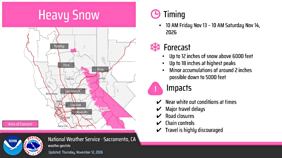
The National Weather Service Sacramento office upgraded the previous Winter Storm Watch to a Winter Storm Warning for elevations above 6,000 feet in the Sierra Nevada, including the El Dorado-Amador County mountain region.


The warning runs from 10 a.m. Friday through 10 a.m. Saturday, Nov. 14.
Forecasters expect the heaviest snowfall Friday night into Saturday morning. Snowfall estimates include:
-
Above 6,000 feet: 6 to 12 inches.
-
Highest mountain peaks: Up to 18 inches.
-
Near 5,000 feet: Approximately 2 inches possible.
Winds could reach 60 mph in exposed mountain areas, creating dangerous conditions, reduced visibility and the potential for near-whiteout conditions.
The National Weather Service cautions that “Travel could be very difficult.” Officials also warn that strong winds could bring down tree branches, cause localized power outages and create additional hazards for motorists.
Highway 50, Interstate 80 and State Route 4 are among the mountain routes that could experience significant winter-weather impacts.
El Dorado County foothills face heavy rain and gusty winds
While mountain communities prepare for snow, residents in the western and central El Dorado County foothills should prepare for substantial rainfall.
The detailed forecast for the high foothills calls for rain beginning overnight Thursday into Friday morning, followed by a much stronger storm system Friday.
Friday’s forecast includes:
-
Rain, with a possibility of thunderstorms.
-
Temperatures falling to approximately 44 degrees by late afternoon.
-
South winds of 11 to 16 mph, with gusts reaching 37 mph.
-
Expected rainfall of 1 to 2 inches.
Rain is expected to continue Friday evening, primarily before 10 p.m., with another quarter to half-inch possible.
The combination of heavy rainfall and gusty winds could create difficult driving conditions, particularly on rural roads, winding foothill highways and routes surrounded by trees.
Residents should also watch for localized flooding, clogged drainage systems and falling branches.
A brief break Saturday before another round of storms
Saturday should bring a temporary improvement, with mostly sunny skies and a high near 51 degrees in the high foothills.
However, the break is expected to be short-lived.
Rain is forecast to return Sunday afternoon, with a 60% chance of precipitation after 4 p.m. Sunday night, the probability increases to 90%.
Rain will continue into Monday morning, followed by a gradual decrease in precipitation.
The unsettled pattern is expected to continue into the middle of next week:
| Day | High | Forecast |
|---|---|---|
| Saturday | 51° | Mostly sunny |
| Sunday | 52° | Rain likely late |
| Monday | 46° | Rain, mainly before 10 a.m. |
| Tuesday | 49° | Mostly sunny, slight rain chance |
| Wednesday | 45° | Rain and snow |
| Thursday | 45° | Rain likely |
Overnight temperatures will generally range from the upper 30s to lower 40s.
The National Weather Service’s broader regional outlook also identifies a series of storm systems bringing additional mountain snow, widespread rainfall and strong southerly winds into early next week.
Travel advisory: Check road conditions before heading east
The greatest concern for El Dorado County residents may be travel along Highway 50 toward South Lake Tahoe and the Sierra Nevada.
Snow accumulation, high winds and reduced visibility can change driving conditions rapidly. Motorists should not assume roads will remain clear simply because conditions are manageable at lower elevations.
Caltrans recommends checking current road conditions and chain requirements before traveling.
Official road and weather resources
Caltrans Highway Information Network
Telephone road-condition information.
511
Caltrans notes that chain requirements can change rapidly as weather and road conditions evolve. Drivers should carry appropriate traction devices and understand California’s chain-control requirements before entering mountain routes.
What to know
Although the foothills are not included in the mountain Winter Storm Warning, the approaching storm will affect communities throughout the county.
Residents should consider securing outdoor furniture and decorations, clearing leaves from storm drains and checking trees near homes and power lines.
Those living in areas with a history of localized flooding should pay particular attention to changing conditions Friday and Sunday night.
For residents heading to South Lake Tahoe, traveling over Echo Summit or crossing Carson Pass, checking road conditions immediately before departure is especially important.
The message from forecasters is straightforward: Winter is arriving in the Sierra Nevada, and the first significant storm system deserves attention from everyone traveling through the region.