EL DORADO COUNTY, Calif. — A bridge built for the modern automobile still carries a story that began in the Gold Rush.
Bucks Bar Bridge, tucked along Bucks Bar Road where the North Fork Cosumnes River cuts through the foothills of southern El Dorado County, is more than a narrow passage between communities. It is a surviving landmark of the county’s transportation history — a place where miners, ranchers, farmers and generations of motorists have confronted the same geographical challenge: getting across a river that can turn dangerous when the water rises.
Today, the 1940 concrete bridge remains open to traffic, but its narrow design and exposure to flooding have prompted El Dorado County to pursue a replacement. The project has advanced through environmental review, yet the latest county capital improvement records indicate that construction has been pushed back again.


For residents who use Bucks Bar Road to reach homes, agricultural properties and the wineries of the Fair Play and Somerset areas, the bridge’s future is both a transportation issue and a question of how to preserve the character of a historic rural corridor.
A crossing born in the Gold Rush
The story begins well before the current bridge, in an era when travelers relied on rudimentary roads and river crossings to move people, livestock, equipment and supplies through the Sierra Nevada foothills.
Local historical accounts trace the name Bucks Bar to a gravel bar where Native American men were mining. White miners referred to the men as “bucks,” a term reflecting the racialized language of the period. The name endured as the crossing and surrounding area developed.
Before a permanent bridge existed, the river could be crossed at a ford when conditions permitted. But a ford was no reliable answer when winter storms sent water surging through the canyon.
In the 1850s, pioneer Daniel Hoag established the Bucks Bar Turnpike and Bridge Co., creating a privately operated toll route and building a bridge upstream of the present crossing. The arrangement offered travelers a way across the river, but the river repeatedly defeated the builders’ efforts. According to local historical research, Hoag’s bridges washed out twice by 1860.
Daniel Robert Carson, a brother of famed frontiersman Kit Carson, subsequently acquired the company and rebuilt the bridge. The next winter brought nearly 80 inches of rain, according to the historical account, and Carson’s bridge was swept away.
Management later passed to Edwin Holt. Another bridge was lost during the winter of 1867-68, extending a cycle of rebuilding and destruction that made maintaining the crossing an expensive and uncertain undertaking.
In 1889, El Dorado County declared the road public, ending the era in which the crossing depended on a private toll-road operation. The river, however, remained an obstacle, and the area would wait decades for the wooden bridge remembered in local photographs.
The covered bridge of 1915
By the early 20th century, improved transportation was becoming increasingly important to the foothill communities south of Placerville. The existing river crossing needed a more durable solution.
In 1915, the El Dorado County Board of Supervisors moved ahead with a covered wooden bridge measuring approximately 70 feet long. Community members helped finance the work through local fundraising, including dances and bake sales. Historical accounts put the community contribution at about $700, supplemented by $3,000 from the county.
The project illustrates how rural infrastructure was often built through a combination of local initiative and public investment. The bridge was not simply a county construction project; it was a community effort to make travel across a difficult landscape more dependable.
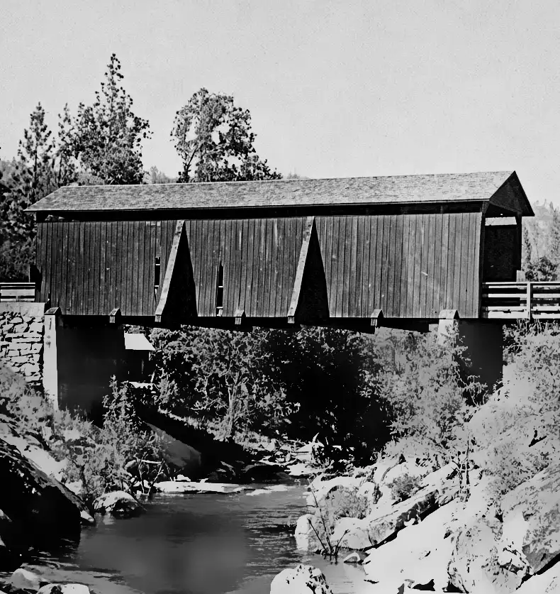
A historic photograph recently shared by local residents offers a glimpse of an earlier Bucks Bar Road bridge. The photograph’s exact date has not been established, but its accompanying account identifies it as predating 1889. That distinction matters: it depicts an earlier chapter in the crossing’s history, not necessarily the 1915 covered bridge.
The image also demonstrates how local history can be recovered through community contributions. Photographs, family recollections and historical research help preserve details that might otherwise disappear when a structure is altered or removed.
The concrete bridge arrives
The covered bridge did not remain in service indefinitely.
County records and historical research identify the present bridge as a 1940 structure. It is a concrete open-spandrel deck arch bridge approximately 70 feet long, built at the location of the earlier crossing and associated with the existing historic masonry approaches.
The California Department of Transportation’s historic concrete-arch inventory lists the Bucks Bar Road bridge over the North Fork Cosumnes River as built in 1940.
The change from wood to concrete reflected a different era of transportation. Motor vehicles were becoming central to everyday life, and bridges had to accommodate traffic patterns and demands that earlier crossings were never designed to handle.
But the concrete structure retained a significant limitation: width.
El Dorado County’s project documentation describes the existing bridge as a one-lane reinforced-concrete structure. Opposing drivers must yield until the bridge is clear, making the crossing a bottleneck on a road that serves both local residents and regional travel.
The bridge’s historic appearance is familiar to generations of motorists, but its constrained roadway geometry is a practical safety concern. On a narrow rural road, limited sight distance and opposing traffic can make an otherwise routine crossing more complicated.
Flooding remains part of the story
The history of Bucks Bar Bridge has always been inseparable from the North Fork Cosumnes River.
The early wooden bridges repeatedly washed away. In more recent decades, flooding has continued to threaten the crossing. Historical accounts identify the major January 1997 flood as an especially dramatic episode, when the bridge was reportedly submerged.
Those events illustrate the challenge of maintaining infrastructure in a steep river canyon. Heavy rainfall can rapidly increase runoff, while debris and rising water can put pressure on bridge openings and approaches.
The replacement project is intended to address the limitations of the existing structure, including its elevation and ability to accommodate high flows. According to the project’s environmental review, the proposed replacement would be a single-span steel-girder bridge with a concrete deck, approximately 120 to 130 feet long.
The longer span is designed to cross the river with a different structural arrangement, while raising the road profile and bridge deck approximately 5 to 8 feet above their current elevations.
The objective is not merely to build a wider bridge. It is to provide a safer, more resilient crossing suited to modern traffic and the river’s flood conditions.
What El Dorado County has approved
The replacement has been under consideration for years, moving through feasibility work, environmental review and project development.
In October 2024, the El Dorado County Board of Supervisors approved Resolution 181-2024, certified the project’s final environmental impact report under the California Environmental Quality Act and authorized the next steps toward construction. Those steps included final design, right-of-way acquisition, permitting and related work.
The county’s official Bucks Bar Road Bridge project page provides access to environmental documents and public-meeting materials.
The project’s Final Environmental Impact Report describes a replacement bridge approximately 120 to 130 feet long, with a single-span steel-girder design and concrete deck. It also identifies the need to remove the existing bridge before construction of the new one.
That work has a direct consequence for residents: the environmental review anticipates a full closure of Bucks Bar Road at the bridge for approximately 10 months during construction. The final timing and traffic-management arrangements should be confirmed through county project updates before motorists plan around the closure.
The county’s schedule has also changed. A 2025 project change document moved the anticipated construction start from fiscal year 2025-26 to 2026-27, citing delays in environmental clearance. The county’s 2026 capital improvement schedule subsequently moved the anticipated start to fiscal year 2027-28, citing delayed federal environmental clearance because some technical studies were outdated.
As of Oct. 11, 2026, those schedule records point to a planned construction start in fiscal year 2027-28 — not an already confirmed construction date. Fiscal years do not align with calendar years, so that schedule generally means a start sometime between July 2027 and June 2028, subject to further changes.
The county’s published schedule is the most useful reference for residents seeking to understand the current timeline. Readers should check the official project page for subsequent announcements before assuming that construction will begin on a particular date.
A rural corridor with regional importance
Bucks Bar Road is part of the network of rural routes that connects the Placerville and Diamond Springs area with communities farther south. It also serves residents traveling to agricultural properties and the Fair Play and Somerset wine regions.
A bridge closure would therefore affect more than the immediate neighborhood. Depending on the final detour plan, residents could face longer trips to work, school, medical appointments and local businesses. Agricultural operations and tourism-related businesses may also need to adjust travel and delivery arrangements.
The county’s environmental review identifies the existing bridge’s single-lane configuration as a transportation limitation. Earlier county project documentation estimated average daily traffic at approximately 4,500 vehicles in 2012. That is a dated traffic figure, not a verified count for 2026, but it demonstrates that the crossing has long carried substantial traffic for a rural road.
The new bridge is intended to improve traffic flow by providing a wider roadway and to reduce flood-related vulnerability through a higher profile and longer span. The precise operational details, including how traffic will be managed before, during and after construction, should be taken from the county’s final design and construction notices.
What will happen to the historic bridge?
The project presents a familiar dilemma in historic preservation: a structure can be locally significant and still be difficult to retain safely in its current form.
The existing bridge reflects the evolution of transportation in El Dorado County, from Gold Rush-era toll roads to community-funded wooden crossings and the concrete infrastructure built for the automobile. Its narrow profile and arch have become recognizable features of the Bucks Bar Road landscape.
Replacing it would change that landscape permanently. The county’s environmental review states that the existing bridge must be removed to construct the proposed replacement.
That makes the period before construction important for documentation. Historic photographs, engineering records, oral histories and accounts from people who have used the crossing for decades can help preserve the story even if the physical structure disappears.
The historic record also requires care. The Gold Rush-era stories, the 1915 covered bridge and the 1940 concrete bridge represent distinct stages of development. Keeping those dates and structures separate helps avoid turning a complex history into a single, simplified legend.
A bridge that tells the county’s story
For more than a century and a half, the crossing at Bucks Bar has reflected the tension between the needs of transportation and the realities of the Sierra foothills.
Pioneer entrepreneurs tried to maintain a toll bridge against destructive winter floods. Residents raised money for a covered wooden replacement. The county later built a concrete arch bridge for the automobile age. Now, another generation faces the task of replacing infrastructure that has outlived its original design assumptions.
The proposed project would bring a wider, higher crossing to a road where drivers have long taken turns passing over a single lane. But the transition will require patience from residents and businesses, particularly if the anticipated 10-month closure proceeds as described in the environmental documents.
For the latest project milestones, environmental records and public notices, residents can consult the El Dorado County Bucks Bar Road Bridge project page and the Board of Supervisors’ October 2024 project approval.
The bridge’s future may be a modern steel span, but its past remains rooted in the same river, canyon and rural communities that made the crossing necessary in the first place.