A window into El Dorado County’s Gold Rush past
For anyone who has driven Highway 50 through the Sierra Nevada, it can be difficult to imagine the same route as a narrow wagon road carved through rugged mountain terrain.
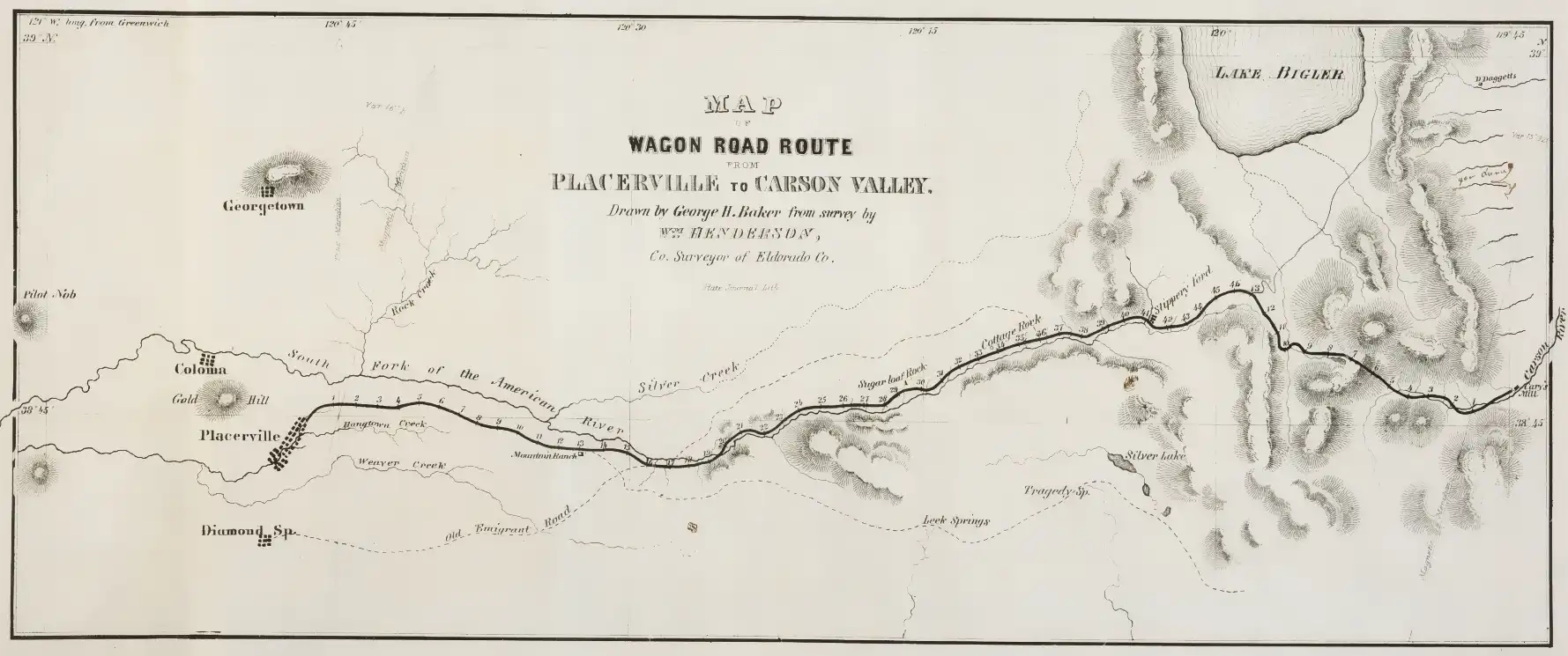
An 1855 map titled “Map of Wagon Road Route from Placerville to Carson Valley” offers a remarkable glimpse into that earlier era — just seven years after James Marshall’s discovery of gold at Sutter’s Mill in Coloma transformed California history.
The map, created by George H. Baker from a survey conducted by William Henderson, the El Dorado County surveyor, traces one of the most important transportation corridors of the Gold Rush period. It was published as part of a California legislative report examining internal improvements and transportation needs.
The road that became a modern corridor
Long before paved highways and mountain passes carried thousands of vehicles daily, the Placerville to Carson Valley Wagon Road served miners, merchants, stage operators and settlers traveling across the Sierra Nevada.
The narrow strip map follows the route from Placerville eastward through the mountains, marking mileage points, geographic features and important landmarks. Researchers studying the map note that it identifies mile markers, water sources and terrain features that guided travelers through one of California’s most challenging mountain crossings.
The connection between Placerville and Carson Valley was strategically important. El Dorado County’s location on the western slope of the Sierra made it a natural gateway between California’s mining communities and the developing settlements east of the mountains.
Many portions of the historic route align with the broader transportation corridor that eventually became U.S. Highway 50, continuing El Dorado County’s role as a gateway across the Sierra.
A different name for Lake Tahoe
One of the details that catches modern viewers’ attention is the map’s reference to “Lake Bigler.”
In 1855, the lake now universally known as Lake Tahoe was still commonly called Lake Bigler, named after John Bigler, California’s third governor. The name would later become part of a long-running debate before “Lake Tahoe” became the accepted name.
For historians and local residents, the name serves as a reminder that maps are more than navigation tools — they capture the language, politics and culture of the moment in which they were created.
A map worth studying closely
At first glance, the Baker map appears to be a simple historical document. A closer look reveals far more: numbered mileage points, mountain features, settlements and clues about how early travelers navigated the Sierra.
One unanswered question remains especially intriguing for local history enthusiasts: What were the names of the individual mile houses or stations identified only by numbers?
Those stops represented the lifelines of the wagon era — places where travelers could rest, obtain supplies and prepare for the next difficult section of mountain road.
“This map is a snapshot of a moment when El Dorado County was still building the infrastructure that would connect California to the rest of the West,” historians say. The document preserves the challenges and ambitions of a young state trying to overcome the Sierra Nevada barrier.
Today, the 1855 Baker map provides more than a look backward. It shows the foundation of a transportation route that continues to shape life in El Dorado County, from Placerville to Lake Tahoe and beyond.
The original map is available through historical collections, including the Huntington Library’s digital archives, where viewers can examine the details of this remarkable Gold Rush-era document.
https://hdl.huntington.org/digital/collection/p15150coll4/id/1936/